
Planning a summer getaway to Aruba? While our world-famous white sands are undeniably beautiful, there is an entirely different side to the One Happy Island waiting to be discovered. From neon street murals in the deep south to hidden natural blowholes along the jagged northern cliffs, the best way to experience Aruba is with a car, an adventurous spirit, and a local’s perspective.
🚗 Local Insider Tip on Wheels: While standard paved roads will easily get you to most of the stops on these routes, exploring Aruba’s rugged, unpaved terrain—like the deep desert trails of Arikok National Park or the hidden northern coves—is best done in a sturdy 4×4 vehicle. Before you book your wheels, be sure to check out our comprehensive list of Aruba Car Rentals to compare local companies, understand insurance requirements, and secure the perfect vehicle for your summer road trip!
To help you skip the tourist traps and navigate like a true resident, we have built the ultimate Interactive Master Map Pack. Below, we break down five expertly curated road-trip layers featured on our master map, complete with local insider tips for each route!
Route 1: The Secret Coves & Snorkel Trail
- ⏰ Best Time to Go: Morning (7:45 AM – 11:30 AM)
- Vibe: Relaxed beach hopping, vibrant marine life, and coastal views.
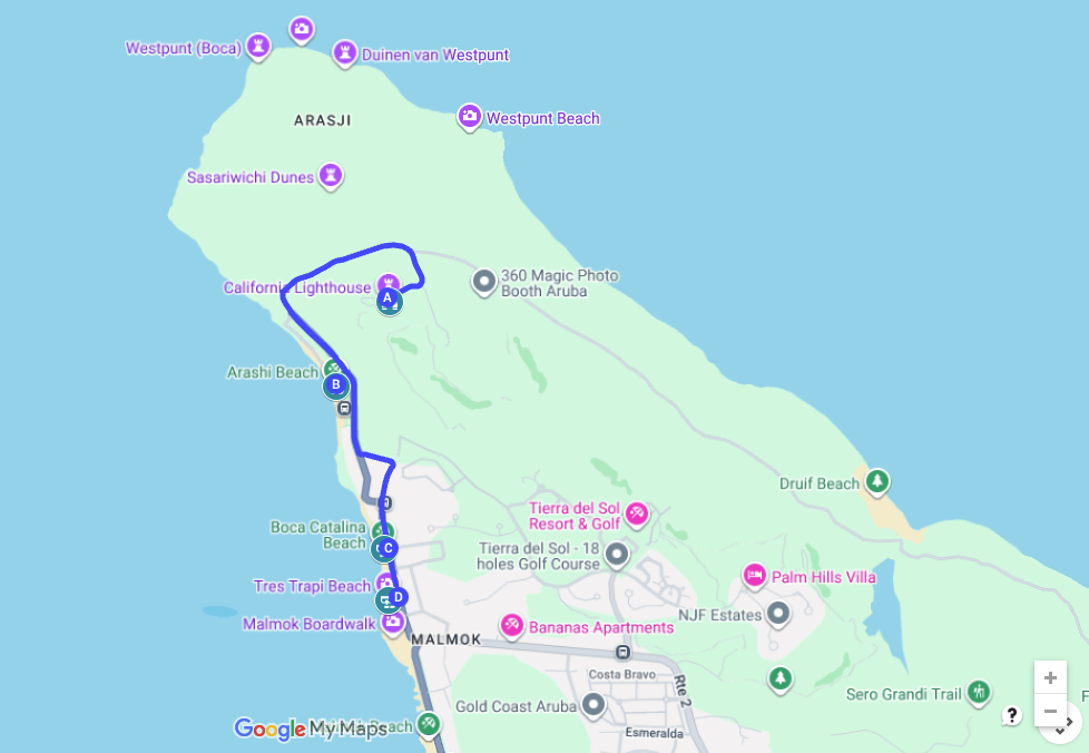
Escape the high-rise crowds early and head to the northernmost tip of the island. This route perfectly balances stunning coastal architecture with Aruba’s best shore-snorkeling spots.
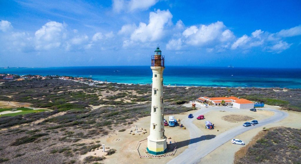
Stop 1: California Lighthouse – Arrive by 8:15 AM to beat the tour buses. Follow the main asphalt road past the lighthouse where it transitions into unpaved dirt tracks. These lead to a rugged limestone shelf featuring hidden natural blowholes and mini-bridges. Safety Note: The terrain is sharp and waves are powerful here—enjoy the views from a safe distance!
Stop 2: Arashi Beach – Your first swim option. Walk to the far right side where the sand meets volcanic rock. Swim out 50 yards to find a vibrant, shallow reef running parallel to shore. Local Snack: Grab a traditional morning pastechi at the beach shack!
Stop 3: Boca Catalina Beach – Your second swim option. This quiet cove offers the most protected shore-snorkeling on the island. Enter from the sandy patch near the palapas and swim toward the right rocky point to explore beautiful brain coral.
Stop 4: Tres Trapi Beach – Your third swim option. Use the carved rock steps to step into knee-deep water. Famous for cushion sea stars on the sandy floor and green sea turtles grazing early in the morning. Please move slowly and respect their space.
💡 Want to extend this route?
- Malmok Beach & Boardwalk: If you aren’t ready to leave the water, pull over along the Fisherman’s Huts/Malmok strip. It features a beautiful, flat pedestrian boardwalk perfect for a scenic coastal stroll, plus shallow entry points into crystal-clear limestone shelves.
- Boca Grandi (For Kite-Surfing Spectating): If you want to see a completely different ocean vibe after snorkeling the calm coves, take a drive to this windy paradise where world-class kite-surfers catch massive air over rolling turquoise waves.
- The Butterfly Farm: Located right near the start of the route along the hotel strip, step into a beautifully meshed tropical rainforest filled with thousands of vibrant, exotic butterflies. It’s an incredible morning photo spot, and your entry ticket gets you free return access for your entire vacation stay!
Route 2: San Nicolas Culture & Sunset
- ⏰ Best Time to Go: Afternoon to Evening (3:00 PM – 7:00 PM)
- Vibe: Massive street murals, island history, and a calm crescent bay sunset.
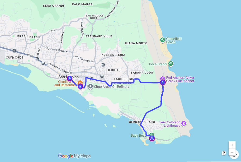
San Nicolas is Aruba’s cultural heart. Heading south in the mid-afternoon gives you the perfect lighting for street photography and lines you up for a spectacular beachside sunset.
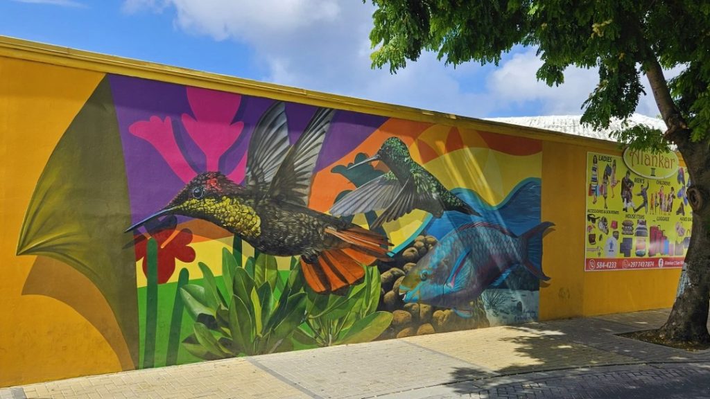
Stop 1: San Nicolas Street Art – Park near the main bus terminal or ArtisA Gallery to begin. Walk the central 6-block area around Main Street to view world-class, massive wall murals painted by global and local artists.
Stop 2: Charlie’s Bar – Operating since 1941, this is an island institution full of decades of fascinating maritime history and memorabilia lining the walls. Pop in for a cold Balashi beer and a plate of their famous jumbo shrimp.
Stop 3: Seroe Colorado Anchor – Drive further south toward the point to see the iconic, giant red marine anchor marking the landscape. It makes for a dramatic, stark photo point against the deep blue backdrop of the rough windward ocean.
Stop 4: Baby Beach – Finish your day at this famous, calm crescent bay. The shallow, protected waters form a natural wading pool. Grab a sunset drink or dinner at Big Mama Grill right on the sand to watch the sky turn pink over the water.
💡 Want to extend this route?
- Rodgers Beach: Tucked right around the corner from Baby Beach, this quiet, narrow bay offers a peaceful local alternative if you want to escape the afternoon crowds.
- San Nicolas Store: Located in a beautifully restored historic building downtown, pop in to grab unique souvenirs and dive into a quick look at local community life.
- Community Museum of Industry: Conveniently situated nearby, it’s a wonderful spot to discover the authentic industrial and cultural history that shaped Aruba’s sunrise city.
Route 3: Arikok Desert Adventure
- ⏰ Best Time to Go: Daytime (9:00 AM – 2:00 PM)
- Vibe: Wild desert terrain, massive caves, and dramatic ocean vistas.
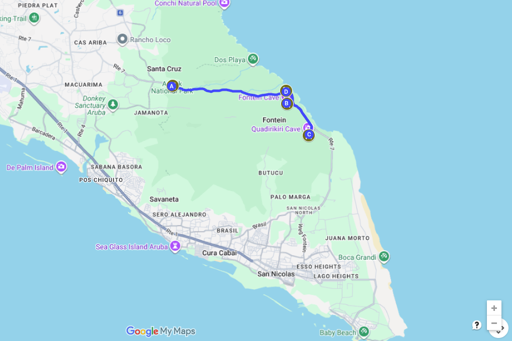
Covering nearly 20% of the island, Arikok National Park is a rugged wonderland of cacti, limestone cliffs, and ancient history.
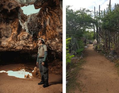
Stop 1: Arikok National Park Visitor Center – Your mandatory starting point. Pay your park conservation fee here to get your day wristbands and a physical trail map before heading past the security gate.
Stop 2: Fontein Cave – Look for the park rangers stationed at the entrance. They offer free, highly insightful history talks inside. Walk deep into this cavern to view authentic brown pictographs left behind by the indigenous Caquetío Arawak tribe.
Stop 3: Quadirikiri Cave – Famous for its two massive, dome-shaped chambers. Walk inside around midday when beams of natural sunlight stream through large holes in the cave roof, illuminating the dark caverns in spectacular fashion.
Stop 4: Boca Prins – Conclude your desert loop where the sand dunes meet the ocean. Walk down the wooden stairs to view the violent, white-capped waves crashing against the jagged cliffs. Do not attempt to swim here—the undercurrents are incredibly dangerous.
💡 Want to extend this route?
- Dos Playa: Meaning ‘Two Beaches,’ this stunning location features two adjacent white-sand coves completely hidden by towering limestone walls. It is a legendary spot for experienced local surfers and offers a spectacular, wild view of Aruba’s untouched coastline. Vehicle & Safety Tip: The unpaved track leading here is heavily rutted—a 4×4 vehicle is highly recommended to navigate it comfortably. The waves and undercurrents are exceptionally powerful here, so stay on the shoreline to soak up the sun and do not attempt to swim.
- The Conchi Natural Pool: For an intense, unforgettable off-road trek, follow the rugged park trails down to this hidden volcanic rock bowl where you can swim protected from the crashing open ocean. (A 4×4 or guided hiking gear is mandatory!).
- Black Stone Beach: Just past the park boundaries near the old suspension bridge, this is the only spot on the island where you can view jagged, jet-black volcanic pebbles glistening against the white surf.
Route 4: Historic Gold & Coastal Heritage
- ⏰ Best Time to Go: Late Afternoon (2:30 PM – 6:00 PM)
- Vibe: Golden-hour history ruins, old legends, and a tree-canopied canyon drive.
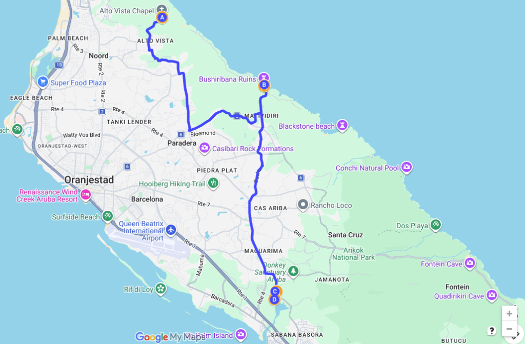
Step back in time to explore the island’s rich historical footprint, tracking the 19th-century gold rush from the northern coast to the southern passages.
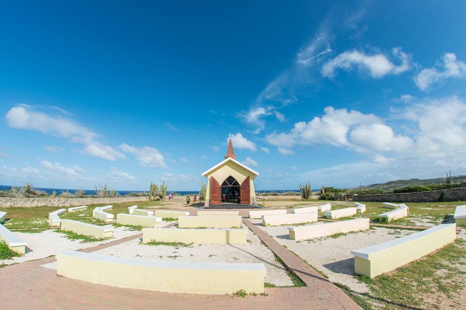
Stop 1: Alto Vista Chapel – Built on the site of the island’s first Catholic church from 1750, this bright yellow chapel sits isolated on a high ridge. Walk the peaceful, winding outdoor labyrinth behind the building.
Stop 2: Bushiribana Gold Mill Ruins – These massive, fortress-like stone ruins on the rugged northern coast processed ore mined from the hills in 1872. Walk inside the open-air structures to photograph the sea crashing through the stone windows.
Stop 3: Frenchman’s Pass (Franse Pas) – A lush, narrow canyon road tucked away near the Spanish Lagoon. Local legend says French pirates clashed with indigenous defenders here in the 17th century. It is a stunning, shaded canopy drive.
Stop 4: Balashi Gold Smelter Ruins – Located right at the edge of Frenchman’s Pass, you can walk the structural foundations and machinery skeletons of this early 1900s gold smelting plant, which replaced Bushiribana using modern steam engines.
💡 Want to extend this route?
- Spanish Lagoon (Spaans Lagoen): Right next to Frenchman’s Pass, this protected marine wetland is one of the largest natural lagoons in the Caribbean. It’s a peaceful spot for birdwatching and viewing coastal mangrove ecosystems.
- Mangel Halto: Just a short drive south from the Balashi ruins, reward yourself after your history tour by stepping into Aruba’s most spectacular mangrove-contained beach. The shallow, neon-blue waters are incredibly calm and perfect for a late afternoon dip.
- The Bushiribana Cave Pool: Located just a short distance from the gold mill ruins, this hidden limestone cavity features a wooden ladder leading down into a crystal-clear, crashing ocean pool. It’s an incredibly popular spot for cliff-jumping! Safety & Local Tip: Check the wave action before jumping, wear sturdy water shoes (the rock is sharp!), and always exercise extreme caution as there are no lifeguards on duty.
Route 5: Central Highlands & Wildlife Trail
- ⏰ Best Time to Go: Early Morning (8:00 AM – 11:30 AM)
- Vibe: Panoramic mountain climbing, ancient boulder gardens, and animal conservation.
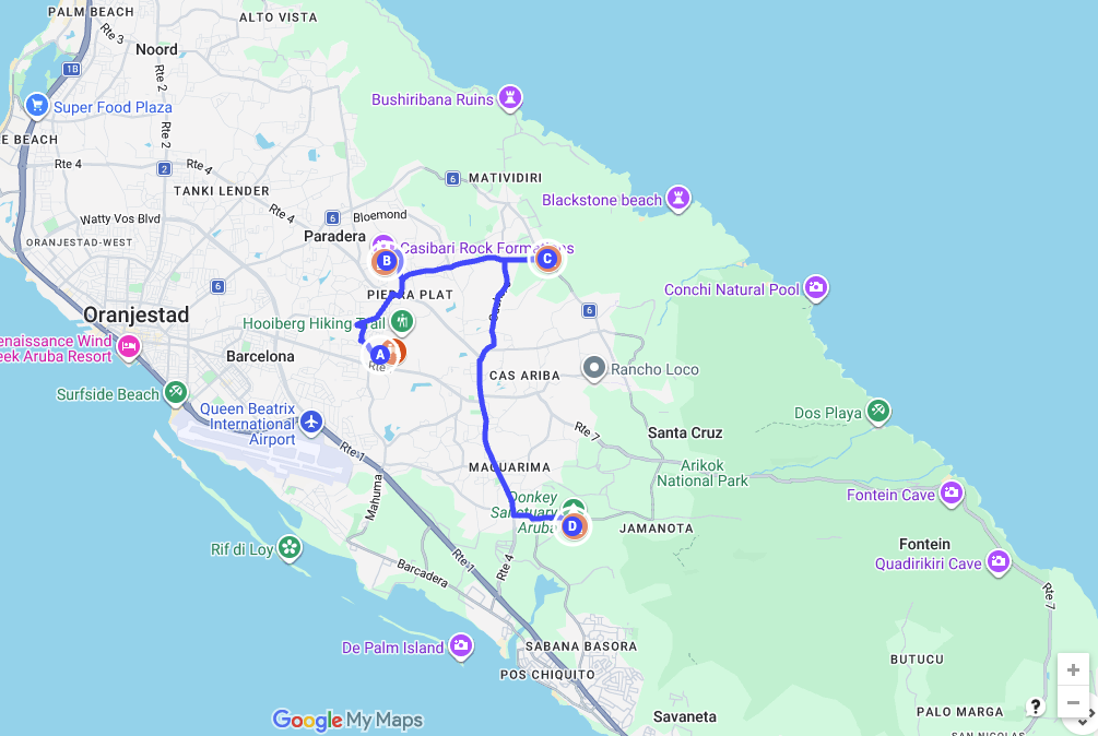
Venture straight into Aruba’s interior to experience the island’s unique geology and connect with local wildlife handlers.
Stop 1: Hooiberg – Arrive by 8:00 AM to tackle the mountain before the heat. Climb the 600+ concrete steps up this iconic, cone-shaped volcanic peak. On a clear morning, the view stretches all the way to Venezuela.
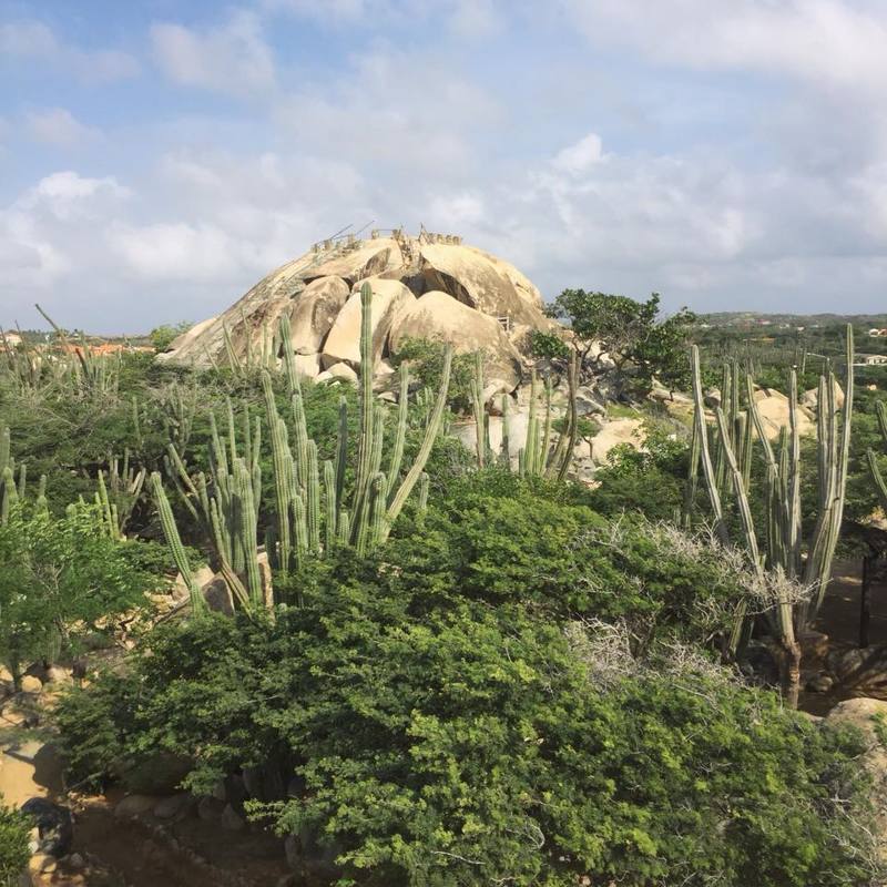
Stop 2: Casibari Rock Formations – Explore these monolithic tonalite boulders rising straight out of the desert floor. Walk the cactus-lined paths and use the stone steps to reach the top of the highest boulder.
Stop 3: Ayo Rock Formations – A more rugged and sacred site. Walk the paved trails winding between these stacked, giant boulders. Look underneath the massive stone overhangs to view authentic, ancient petroglyphs carved by early Arawak settlers.
Stop 4: Donkey Sanctuary Aruba – Wrap up your tour at this peaceful, volunteer-run haven for the island’s protected wild donkeys. Grab a coffee at the visitor center patio where you can feed the friendly donkeys alfalfa pellets.
💡 Want to extend this route?
- Philips Animal Garden: If your family loved the Donkey Sanctuary, head over to this fantastic, non-profit rehabilitation center. You can get up close, interactive, and safely feed a wide variety of rescued exotic animals and birds.
- Ostrich Farm: Located a short distance from the Ayo Rock Formations, take a quick detour to hang out with dozens of giant ostriches and emus. They offer brief, fun guided tours every half hour that are perfect for kids and animal lovers.
🎁 Open the Master Road-Trip Map on Your Phone Right Now!
No forms to fill out, no email required—just pure local knowledge to help you make the most of your summer vacation. Click the button below to instantly load all 5 curated driving routes, insider tips, and precise offline-ready GPS paths directly into your personal Google Maps app. Save it to your account, secure your 4×4 rental vehicle, and you’re completely ready to explore Aruba like a local!
Open the Free Summer Map Pack!
👉 Real-Time Trip Planning Resources:
- Need the perfect vehicle for the north coast tracks? Check out our comprehensive list of Aruba Car Rentals
- Wondering where to stop for lunch or dinner along the paths? See our curated Aruba Restaurant Guide
- Looking for more guided adventures? Browse our trusted Aruba Tour Operators Guide.